Hauptinhalt
Perfect precision and brilliance
Gerhard Mercator was born Gerhard Kremer southwest of Antwerp in Flanders in 1512. He later adopted the Latin name Gerardus Mercator as was common practice among scholars at that time.
He lived at a time of great upheavals and innovations. These were inspired in religion by Martin Luther's Reformation theses, in cosmology by Nicolaus Copernicus’ groundbreaking findings, and in geography by the discovery of “new worlds”.
The mathematically gifted Mercator is considered to have been one of the conquerors of the Ptolemaic view of the world and an innovator of cartography. His work was revolutionary, as he combined form and content in a way that was mathematically sound but also artistic. The external form that Mercator gave his maps remained the model for generations.
![[Translate to Englisch:] Der Erdglobus von Gerhard Mercator](/securedl/sdl-eyJ0eXAiOiJKV1QiLCJhbGciOiJIUzI1NiJ9.eyJpYXQiOjE3NzUzMjIyNTMsImV4cCI6MTc3NTQxMjI1MywidXNlciI6MCwiZ3JvdXBzIjpbMCwtMV0sImZpbGUiOiJmaWxlYWRtaW4vX3Byb2Nlc3NlZF8vMC8wL2NzbV9nbG9idXNfbWVyY2F0b3JfRFNDXzE2MjFfMzE0Y2ZlYzM4MC5qcGciLCJwYWdlIjo1Mn0.HmBrrqWofJ06qjVwIwioUVLaeRmbhc83H07PDUC948I/csm_globus_mercator_DSC_1621_314cfec380.jpg)
![[Translate to Englisch:] Der Erdglobus von Gerhard Mercator](/securedl/sdl-eyJ0eXAiOiJKV1QiLCJhbGciOiJIUzI1NiJ9.eyJpYXQiOjE3NzUzMjIyNTMsImV4cCI6MTc3NTQxMjI1MywidXNlciI6MCwiZ3JvdXBzIjpbMCwtMV0sImZpbGUiOiJmaWxlYWRtaW4vX3Byb2Nlc3NlZF8vOS81L2NzbV9nbG9idXNfbWVyY2F0b3JfRFNDXzE2MjdfYzY4YzQ2OTljMy5qcGciLCJwYWdlIjo1Mn0.Lu_WypXwFfR1qFMs-hcYai1cl1fSbOL9IG22fNdhoAo/csm_globus_mercator_DSC_1627_c68c4699c3.jpg)
![[Translate to Englisch:] Der Erdglobus von Gerhard Mercator](/securedl/sdl-eyJ0eXAiOiJKV1QiLCJhbGciOiJIUzI1NiJ9.eyJpYXQiOjE3NzUzMjIyNTMsImV4cCI6MTc3NTQxMjI1MywidXNlciI6MCwiZ3JvdXBzIjpbMCwtMV0sImZpbGUiOiJmaWxlYWRtaW4vX3Byb2Nlc3NlZF8vMi8zL2NzbV9nbG9idXNfbWVyY2F0b3JfRFNDXzE2NDZfMjFlZGE3NjIyNy5qcGciLCJwYWdlIjo1Mn0.UixnLVKpjDm8VEm_IutoFrQXwYAAn5rgyLBwEV0TxD4/csm_globus_mercator_DSC_1646_21eda76227.jpg)
![[Translate to Englisch:] Der Erdglobus von Gerhard Mercator](/securedl/sdl-eyJ0eXAiOiJKV1QiLCJhbGciOiJIUzI1NiJ9.eyJpYXQiOjE3NzUzMjIyNTMsImV4cCI6MTc3NTQxMjI1MywidXNlciI6MCwiZ3JvdXBzIjpbMCwtMV0sImZpbGUiOiJmaWxlYWRtaW4vX3Byb2Nlc3NlZF8vZS8wL2NzbV9nbG9idXNfbWVyY2F0b3JfRFNDXzE2MzZfNDFjNzg4OTE2Yy5qcGciLCJwYWdlIjo1Mn0.t5tybsS7roAtrWXZLCj-jeR1M5Cl04f9fd0nG_LHApw/csm_globus_mercator_DSC_1636_41c788916c.jpg)
Details of the terrestrial globe
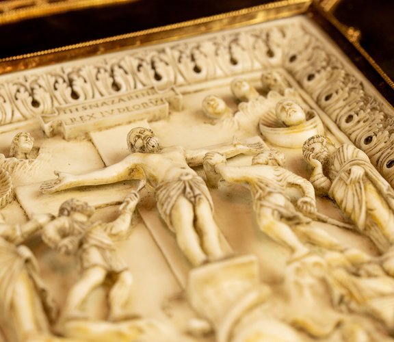
A cartouche is visible in the southern Pacific Ocean on the terrestrial globe that identifies Gerhard Mercator (1512-1594) as its creator.
The Latin wording also contains a kind of copyright: "Edebat Gerardus Mercator Rupelmundanus cum privilegio Ces(areae) Maiestatis ad an: sex Lovanij an: 1541", meaning "Published by Gerard Mercator of Rupelmunde at Leuven under the patent of His Imperial Majesty for six years in the year 1541.” Mercator accordingly had the rights to the globe he had produced in Leuven (Flanders) secured by an imperial patent for six years. It is interesting to note that this cartouche is surrounded by sea monsters – probably to emphasise how seriously he meant it.
Sea monsters had appeared on medieval depictions of the world as early as the 10th century and were very popular in Mercator's time. They adorned the depictions, entertained and sometimes bewildered the viewer. They could also be used to conveniently fill extensive blank spaces on maps. These strange creatures were also often depicted on maps in waters that lay in somewhat unfamiliar areas as a symbol of the strange and threatening. In addition to the sea monsters in the Pacific Ocean that we have mentioned above, Mercator also drew some in the Atlantic Ocean northwest of Spain on his globe.
North America is still depicted on Mercator's globe as largely unexplored territory and it merges seamlessly into vast Arctic regions. Most of the place entries are concentrated along the coastlines. Mercator certainly copied many places from various nautical charts of the time. He depicted the Caribbean islands and Central America – areas that travellers, explorers and conquerors documented very well in Mercator's time – in a sophisticated manner.
And he drew on reports by Marco Polo, the Venetian who had travelled to the Orient, in order to improve his representation of the Asian continent. His over-extension of Asia and the excessive distance he put between China and Japan can be traced back to the mathematician and cartographer Paolo dal Pozzo Toscanelli. The latter had misunderstood Marco Polo in some respects and had also assumed that Asia was even larger than Ptolemy did – and Ptolemy had already overestimated it.
As well as including an astonishingly large number of places on the African continent, Mercator provided information about its geographical features and describes animals found in individual regions. For example, in North Africa: Libya: Hic sunt vast(a)e solitudines et deserta leonibus, tigridibus, pardis, et elephantibus abundantia / North Africa: Here are vast wilds and deserts with many lions, tiger-like animals, panthers and elephants.
Mercator significantly corrected people's understanding of the shape of the European continent. This becomes particularly clear when one compares his representation of Europe with Ptolemy's of the Mediterranean: it is clearly less extensive. Due to the high density of places, Mercator decided to collect the names of the European empires and their most important cities on a large sheet of cartridge and to number them.
Mercator believed that a comprehensive description should also include what surrounded the earth. His celestial globe from 1551 shows the various constellations as impressive figures in an antiquated style. However, in his map image of the terrestrial globe, he only occasionally records important stars (29 in all) as aids to orientation, especially in the vicinity of straits that would be hard to navigate and in desert areas.
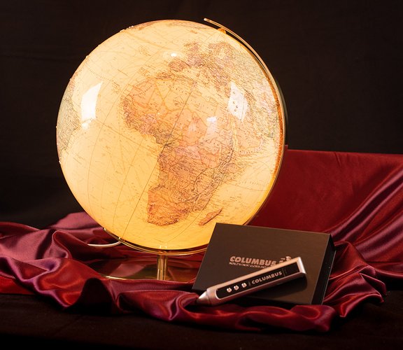
The globe "Historischer Erdglobus von Mercator (1541)" exclusively facsimulated by DOMI in cooperation with the publishing house Müller & Schindler, the Faksimile Verlag, and the National Maritime Museum in Greenwich in England is a masterpiece of craftsmanship in the field of globe production.
![[Translate to Englisch:] Der Erdglobus von Gerhard Mercator](/securedl/sdl-eyJ0eXAiOiJKV1QiLCJhbGciOiJIUzI1NiJ9.eyJpYXQiOjE3NzUzMjIyNTMsImV4cCI6MTc3NTQxMjI1MywidXNlciI6MCwiZ3JvdXBzIjpbMCwtMV0sImZpbGUiOiJmaWxlYWRtaW4vY29udGVudC9HbG9idXMvTWVyY2F0b3IvbWVyY2F0bzEuanBnIiwicGFnZSI6NTJ9.d1AWMlifXb4rvQWnhWuGZPsjpTBmIQVByM088B8jY0M/mercato1.jpg)
In order to meet the demands of our customers, each facsimile globe is laminated and elaborately manufactured by hand in Germany by COLUMBUS, the world market leader in globe manufacture. The look of the facsimile globe is additionally rounded off by the exclusive jewel chain including SWAROVSKI trimmings and illuminated by an amber lamp on the inside.
![[Translate to Englisch:] Der Erdglobus von Gerhard Mercator](/securedl/sdl-eyJ0eXAiOiJKV1QiLCJhbGciOiJIUzI1NiJ9.eyJpYXQiOjE3NzUzMjIyNTMsImV4cCI6MTc3NTQxMjI1MywidXNlciI6MCwiZ3JvdXBzIjpbMCwtMV0sImZpbGUiOiJmaWxlYWRtaW4vY29udGVudC9HbG9idXMvTWVyY2F0b3IvbWVyY2F0bzIuanBnIiwicGFnZSI6NTJ9.fdDkK62wgh-GDySya93KW4sPHxofiJCNpBbg8jaU53U/mercato2.jpg)
In addition, the globe not only impresses with its unique map design and the elegant presentation, but also with the multimedia support via audio pen. In cooperation with museums and scientists, we have processed historical information in order to make it accessible to the world public. A unique WORLD FIRST, which is strictly limited to 3,000 copies.
![[Translate to Englisch:] Der Erdglobus von Gerhard Mercator](/securedl/sdl-eyJ0eXAiOiJKV1QiLCJhbGciOiJIUzI1NiJ9.eyJpYXQiOjE3NzUzMjIyNTMsImV4cCI6MTc3NTQxMjI1MywidXNlciI6MCwiZ3JvdXBzIjpbMCwtMV0sImZpbGUiOiJmaWxlYWRtaW4vY29udGVudC9HbG9idXMvTWVyY2F0b3IvbWVyY2F0bzMuanBnIiwicGFnZSI6NTJ9.jYaUMlSsduqHGD0KrtC-Sk2daG4x48RQ4HvZ8CgtUMs/mercato3.jpg)
Who was Gerhard Mercator?
Gerhard Mercator was born Gerhard Kremer in 1512 southwest of Antwerp in Flanders and later took the Latin name Gerardus Mercator, as was common among scholars of the time. He lived in a time of great upheaval and renewal: in the religious field through the reformatory theses of Martin Luther, in the field of cosmology through the groundbreaking findings of Nicolaus Copernicus and in the field of geography through the discovery of "new worlds". Finally, the printing press allowed the duplication and access of knowledge on an unprecedented scale. Mercator was educated in mathematics, geography, philosophy, astrology, and natural history. He was also very familiar with the technique of copperplate engraving: he made the engraved maps that were to cover the globe of his teacher Gemma Frisius himself. Suspected of "Lutherey," the scholar was imprisoned for several months. That was probably an important reason for his move to the more tolerant Duisburg, where he was able to continue and expand his cartographic and artistic-technical work as part of a modern publishing activity as an entrepreneur. His most famous patron was Charles V. As already mentioned, ten years later Mercator supplemented the terrestrial globe of 1541 with a celestial globe; both globes should form a unit. Mercator's claim was always that of a cosmographically comprehensive description of the world: earthly and heavenly. An ambitious project at the time, but in keeping with Mercator's motto: Suprema mundi optima - Only the highest achievements are the most precious thing in the world.